
Content: General | Data and Methodology | Datasets | Citation
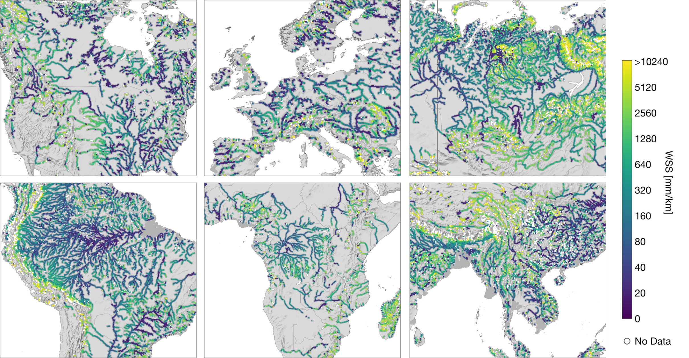
Water Surface Slope from Satellite Altimetry (WSS) is a fundamental parameter in the calculation of river discharge which is one of the Essential Climate Variables (ECVs) defined by the Global Climate Oberserving System (GCOS). In addition, correcting Water Surface Elevation (WSE) observations from satellite altimetry for WSS can significantly improve the accuracy of the resulting water level time series. Depending on river morphology, regulation, bed material, and basin size, the WSS can be highly variable in both space and time.
In 2023, DGFI-TUM published a new global dataset ICESat-2 river surface slope (IRIS). It contains reach-scale average and extreme WSS derived from ICESat-2 observations as a supplement to the SWOT Mission River Database (SWORD). Using ICESat-2's unique measurement geometry with six parallel lidar beams, an instantaneous WSS is determined across beam pairs and along individual beams. Within the IRIS dataset, the median of all instantaneous WSS observations is given with the observed minimum and maximum WSS per SWORD reach. Additionally, IRIS contains the number of observations and their standard deviation. All parameters are given separately for the different methods (across and along beams) and as a combined value that has the largest spatial and temporal coverage. The methodology is described in detail in Scherer, 2022.
| Dataset | Input Data | SWORD | Area | ||
|---|---|---|---|---|---|
| IRISv2.6 | ICESat-2 ATL13 v6 (Cycle 1-23) (October 2018 to May 2024) |
Version v16 | global | Data Access | Map |
| IRISv2.1 | ICESat-2 ATL13 v6 (Cycle 1-19) (October 2018 to April 2023) |
Version v16 | global | Data Access | |
| IRISv2 | ICESat-2 ATL13 v6 (Cycle 1-19) (October 2018 to April 2023) |
Version v15 | global | Data Access | |
| IRISv1 | ICESat-2 ATL13 v5 (Cycle 1-16) (October 2018 to August 2022) |
Version v2 | global | Data Access | |
| IRISv0 | ICESat-2 ATL13 v5 (Cycle 1-13) (October 2018 to October 2021) |
Version v1 | selected reaches see Scherer et al., 2022 |
Data Access |
References:
Scherer D., Schwatke C., Dettmering D., Seitz F. .: ICESat-2 Based River Surface Slope and Its Impact on Water Level Time Series From Satellite Altimetry. Water Resources Research, doi: 10.1029/2022WR032842, 2022
Jasinski M., Stoll J., Hancock D., Robbins J., Nattala J., Morison J., Jones B., Ondrusek M., Pavelsky T.M., Parrish C. and the ICESat-2-Science-Team: ATLAS/ICESat-2 L3A Inland Water Surface Height, Version 5. [Dataset], 2021
Altenau E.H., Pavelsky T.M., Durand, M.T., Yang X., Frasson, R.P.d.M., Bendezu, L. : SWOT River Database (SWORD) [Data set] Zenodo doi: 10.5281/zenodo.3898569, 2021