Content: General | Processing Strategy | Data Holding | Data Versions | Data Formats | Citation
General
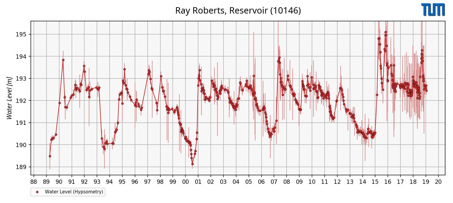
The water level time series for lakes and reservoir is derived from a hypsometric curve in combination with surface area.
The hypsometric curve describes the relationship between water levels and surface areas of a lake or reservoir.
This information is essential for the estimation of the time series of volume variations but provides also important information.
In the figure (right), the water level time series derived from the hypsometic curve and surface area of Ray Roberts is shown.
The water level time series from hypsometry has the potential to provided information back to 1984 where altimetry measurement over inland water is not possible.
Processing Strategy
This product is estimated within the processing strategry of volume variations for lakes and reservoirs.
Therefore, more information can be found here.
Data Holding
DAHITI currently provides 71 water level time series based on surface areas and hypsometric curves distributed over all continents, except Antarctica.
In Africa (9 time series), Asia (8), Australia (1), Europe (4), North America (42), and South America (7) water occurrence masks are available.
The water level time series in DAHITI are freely available and can be downloaded after a short registration process.
The amount of water level time series is permanently increasing.
Data Versions
This product is processed in the processing chain of volume variations.
More information can be found here.
Water level time series (Hypsometry) can be download in ASCII, NetCDF, CSV and JSON format.
--- ASCII ---
# DAHITI-ID : 10146
# Target name : Ray Roberts, Reservoir
# Continent : North America
# Country : United States of America
# Longitude : -97.0557
# Latitude : 33.3615
# Points : 543
# Software : 1.00
# Download : 2020-03-09 08:51:36 (UTC)
# Dataset : water-level-hypsometry
# ----------------------------------------
# column 1 : date [yyyy-mm-dd]
# column 2 : water level from hypsometry[m]
# column 3 : error [m]
# ----------------------------------------
1989-06-10 189.486 0.597
1989-07-28 190.240 0.147
1989-08-29 190.298 0.125
...
2019-03-09 192.559 0.185
2019-03-17 192.680 0.219
2019-03-25 192.457 0.193
--- NetCDF ---
user@dahiti:/> ncdump -h 10146_volume_variation.nc
netcdf \10146_water_level_hypsometry {
dimensions:
time = 543 ;
variables:
string date(time) ;
date:standard_name = "UTC Date (YYYY-MM-DD)" ;
float water_level(time) ;
water_level:standard_name = "Water Levels derived from Hypsometry and Surface Area" ;
water_level:source = "Hypsometry and Surface Area" ;
water_level:unit = "m" ;
float error(time) ;
error:standard_name = "Error of Water Levels" ;
error:unit = "m" ;
// global attributes:
:dahiti_id = "10146" ;
:dataset = "water-level-hypsometry" ;
:target_name = "Ray Roberts, Reservoir" ;
:location = "None" ;
:continent = "North America" ;
:country = "United States of America" ;
:longitute = "-97.0557" ;
:latitude = "33.3615" ;
:software = "1.0" ;
:institution = "DGFI-TUM" ;
:source = "DAHITI" ;
:url = "https://dahiti.dgfi.tum.de/10146/" ;
:creation_date = "2020-03-09 08:52:13" ;
}
--- CSV ---
date,water level,error
1989-06-10,189.486,0.597
1989-07-28,190.240,0.147
1989-08-29,190.298,0.125
...
2019-03-09,192.559,0.185
2019-03-17,192.680,0.219
2019-03-25,192.457,0.193
--- JSON ---
{
"info": {
"dahiti_id": "10146",
"target_name": "Ray Roberts, Reservoir",
"location": "None",
"latitude": "33.3615",
"continent": "North America",
"country": "United States of America"
"longitute": "-97.0557",
"software": "1.0",
"source": "DAHITI",
"institution": "DGFI-TUM",
"url": "https://dahiti.dgfi.tum.de/10146/",
"dataset": "water-level-hypsometry",
"creation_date": "2020-03-09 08:53:56",
},
"data": [
{"date": "1989-06-10", "water_level": 189.485682689, "error": 0.597394299016},
{"date": "1989-07-28", "water_level": 190.239665113, "error": 0.146681849487},
{"date": "1989-08-29", "water_level": 190.298076291, "error": 0.125468587956},
...
{"date": "2019-03-09", "water_level": 192.558525845, "error": 0.184601513883},
{"date": "2019-03-17", "water_level": 192.680333451, "error": 0.218718950577},
{"date": "2019-03-25", "water_level": 192.457000668, "error": 0.19283227465}
]
}
Citation
Don't forget to cite!
If you are using time series of volume variations from DAHITI in your work, please cite the following publication:
Schwatke C., Dettmering D., and Seitz F.:
Volume Variations of Small Inland Water Bodies from a Combination of Satellite Altimetry and Optical Imagery. Remote Sensing, 12(10), 1606, doi:
10.3390/rs12101606, 2020