Content: General | Processing Strategy | Data Holding | Data Versions | Data Formats | Citation
General
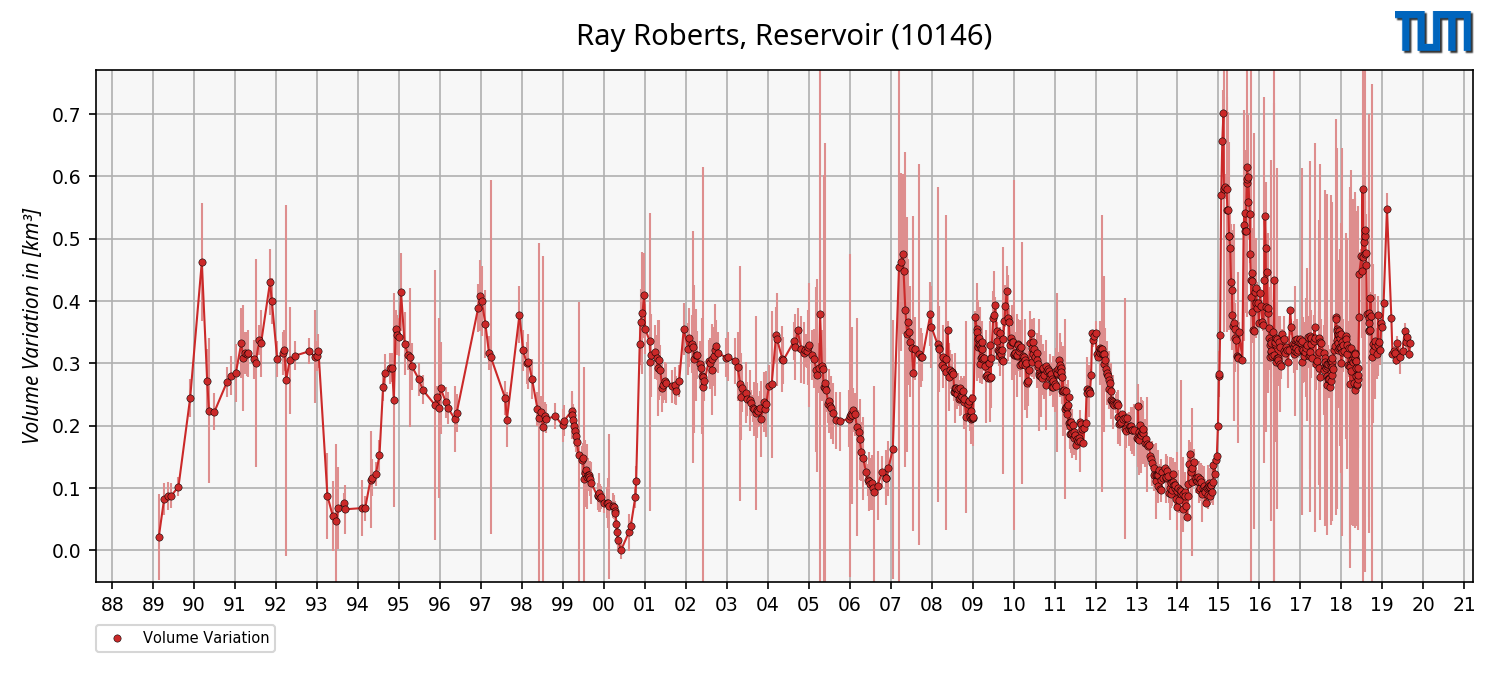
This product contains time series of volume variations for lakes and reservoir which are estimated by using remote sensing data only.
However, the resulting volume time series are variations with respect to the minimum observed surface area from optical imagery since the full bathymetry of lakes cannot be measured by using remote sensing data only.
This product can provide important information for hydrological applications such as models.
For Ray Roberts Lake, the time series of volume variations is shown as an example in the right figure.
Processing Strategy
The approach for estimating volume variations of lakes and reservoirs uses water levels from satellite altimetry and surface areas from optical imagery.
The approach is divided into three parts.
In the first part, a hypsometry model based on the new modified Strahler approach is computed by combining water levels and surface areas.
The hypsometry model describes the dependency between water levels and surface areas of lakes and reservoirs.
In the second part, a bathymetry between minimum and maximum surface area is computed.
For this purpose, land-water masks are stacked using water levels derived from the hypsometry model.
Finally, water levels and surface areas are intersected with the bathymetry to estimate a time series of volume variations in relation to the minimum observed surface area.
Data Holding
DAHITI currently provides 5257 time series of volume variations distributed over all continents, except Antarctica.
In Africa (56 time series), Asia (174), Australia (11), Europe (4637), North America (310), and South America (68) water occurrence masks are available.
The time series of volume variations in DAHITI are freely available and can be downloaded after a short registration process.
The amount of time series of volume variations is permanently increasing.
Data Versions
--- Version v1.20 ---
This version uses the standard approach described in Schwatke et al. (2020).
Used Data: Water level time series (v6.0) and daily merged composites based on Landsat-4/-5/-7/-8 and Sentinel-2A/-2B scenes (v1.20).
Time series of volume variations can be download in ASCII, NetCDF, CSV and JSON format.
--- ASCII ---
# DAHITI-ID : 10146
# Target name : Ray Roberts, Reservoir
# Continent : North America
# Country : United States of America
# Longitude : -97.0557
# Latitude : 33.3615
# Points : 873
# Software : 1.00
# Download : 2020-03-09 08:15:43 (UTC)
# Dataset : volume-variation
# ----------------------------------------
# column 1 : date [yyyy-mm-dd]
# column 2 : volume variation [km3]
# column 3 : error [km3]
# ----------------------------------------
1989-06-10 0.021 0.069
1989-07-28 0.083 0.026
1989-08-29 0.088 0.022
...
2019-11-28 0.342 0.007
2019-12-18 0.315 0.007
2019-12-28 0.333 0.006
--- NetCDF ---
user@dahiti:/> ncdump -h 10146_volume_variation.nc
netcdf \10146_volume_variation {
dimensions:
time = 873 ;
variables:
string date(time) ;
date:standard_name = "UTC Date (YYYY-MM-DD)" ;
float volume_variation(time) ;
volume_variation:standard_name = "Volume Variations" ;
volume_variation:unit = "km3" ;
float error(time) ;
error:standard_name = "Error of Volume Variations" ;
error:unit = "km3" ;
// global attributes:
:dahiti_id = "10146" ;
:dataset = "volume-variation" ;
:target_name = "Ray Roberts, Reservoir" ;
:location = "None" ;
:continent = "North America" ;
:country = "United States of America" ;
:longitute = "-97.0557" ;
:latitude = "33.3615" ;
:software = "1.0" ;
:institution = "DGFI-TUM" ;
:source = "DAHITI" ;
:url = "https://dahiti.dgfi.tum.de/10146/" ;
:creation_date = "2020-03-09 08:16:19" ;
}
--- CSV ---
date,volume variation,error
1989-06-10,0.021,0.069
1989-07-28,0.083,0.026
1989-08-29,0.088,0.022
...
2019-11-28,0.342,0.007
2019-12-18,0.315,0.007
2019-12-28,0.333,0.006
--- JSON ---
{
"info": {
"dahiti_id": "10146",
"target_name": "Ray Roberts, Reservoir",
"location": "None",
"latitude": "33.3615",
"continent": "North America",
"country": "United States of America"
"longitute": "-97.0557",
"software": "1.0",
"source": "DAHITI",
"institution": "DGFI-TUM",
"url": "https://dahiti.dgfi.tum.de/10146/",
"dataset": "volume-variation",
"creation_date": "2020-03-09 08:17:38",
},
"data": [
{"date": "1989-06-10", "error": 0.06924, "volume_variation": 0.02121},
{"date": "1989-07-28", "error": 0.02558, "volume_variation": 0.08271},
{"date": "1989-08-29", "error": 0.02209, "volume_variation": 0.08783},
...
{"date": "2019-11-28", "error": 0.00718, "volume_variation": 0.34231},
{"date": "2019-12-18", "error": 0.0075, "volume_variation": 0.31471},
{"date": "2019-12-28", "error": 0.00597, "volume_variation": 0.33323}
]
}
Citation
Don't forget to cite!
If you are using time series of volume variations from DAHITI in your work, please cite the following publication:
Schwatke C., Dettmering D., and Seitz F.:
Volume Variations of Small Inland Water Bodies from a Combination of Satellite Altimetry and Optical Imagery. Remote Sensing, 12(10), 1606, doi:
10.3390/rs12101606, 2020