This product contains river discharge time series which are estimated by using remote sensing data only.
It can provide important information for hydrological applications such as models.
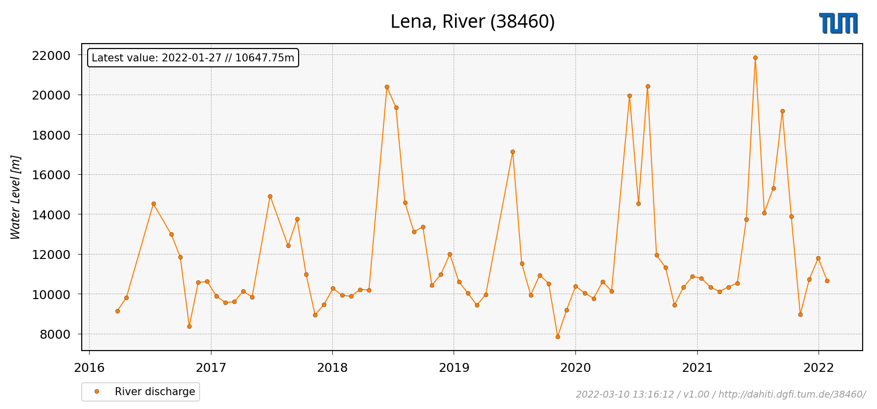
The figure on the right shows as an example the discharge for the Lena, River.
Processing Strategy
The approach for estimating river discharge uses water levels from satellite altimetry and surface areas from optical imagery as input data.
The river discharge is computed by using physical flow equations at a single cross-section.
The methodology is described in detail in Scherer et al., 2020.
Data Holding
DAHITI currently provides 7 time series of river discharge distributed over all continents, except Antarctica.
In Africa (0 time series), Asia (1), Australia (0), Europe (0), North America (6), and South America (0) water occurrence masks are available.
The time series of river discharge in DAHITI are freely available and can be downloaded after a short registration process.
The amount of time series of river discharge is permanently increasing.
Data Versions
--- Version v1.00 ---
This version uses the standard approach described in Scherer et al. (2020).
Data Format
Time series of volume variations can be download in ASCII, NetCDF, CSV and JSON format.
--- ASCII ---
# DAHITI-ID : 38460
# Target name : Lena River
# Continent : Asia
# Country : Russia
# Longitude : -122.9178
# Latitude : 60.5755
# Points : 71
# Software : 1.00
# Download : 2022-03-25 15:38:09 (UTC)
# Dataset : discharge
# ----------------------------------------
# column 1 : date [yyyy-mm-dd]
# column 2 : river discharge[m3s]
# column 3 : error [m3s]
# ----------------------------------------
2016-03-26 9144.408 None
2016-04-22 9805.834 None
2016-07-12 14519.398 None
...
2021-12-04 10721.145 None
2021-12-31 11794.599 None
2022-01-27 10647.749 None
--- NetCDF ---
user@dahiti:/> ncdump -h 38460_discharge.nc
netcdf \38460_discharge {
dimensions:
time = 71 ;
variables:
string date(time) ;
date:standard_name = "UTC Date (YYYY-MM-DD)" ;
float discharge(time) ;
discharge:standard_name = "River Discharge derived from Water Levels, Surface Areas and Hypsometry" ;
discharge:source = "Water Levels, Surface Areas and Hypsometry" ;
discharge:unit = "m3s" ;
float error(time) ;
error:standard_name = "Error of River Discharge" ;
error:unit = "m3s" ;
Don't forget to cite!
If you are using time series of volume variations from DAHITI in your work, please cite the following publication:
Scherer D., Schwatke C., Dettmering D., and Seitz F.: Long-Term Discharge Estimation for the Lower Mississippi River Using Satellite Altimetry and Remote Sensing Images. Remote Sensing, 12(17), 2693, doi:10.3390/rs12172693, 2020