Content: General | Processing Strategy | Data Holding | Data Versions | Data Formats | Citation
General
The product of the water occurrence mask is created in the processing of the surface area time series.
It is used for filling of remaining data gaps caused by voids, clouds or snow.
However, it can also provide important information for hydrological applications since it contains information about water occurrence of a lake or reservoir since the 1980s.
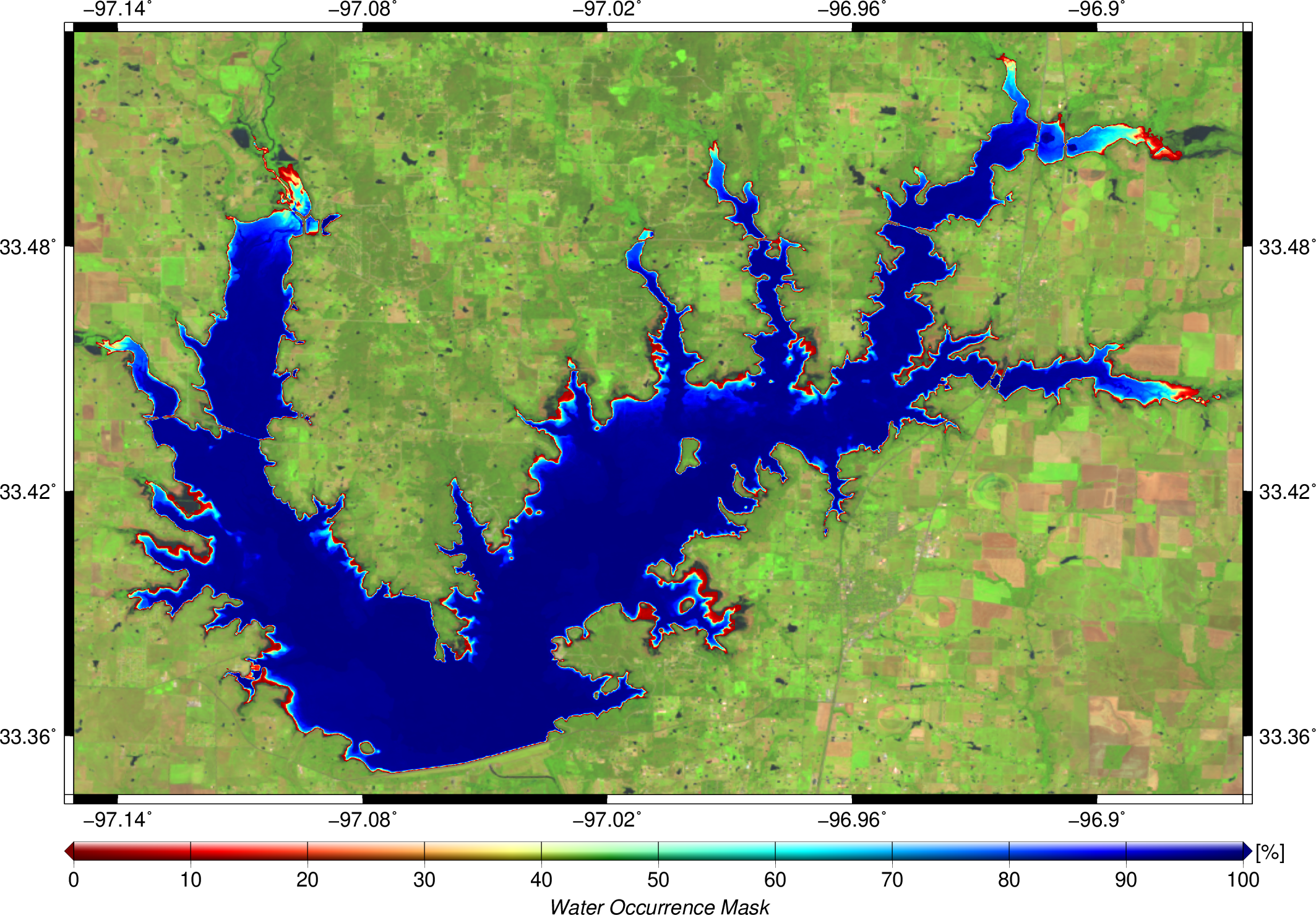
An exemplary water occurrence mask is shown for Ray Roberts Lake in the right figure.
Processing Strategy
This product is estimated within the processing strategry of surface areas for lakes and reservoirs.
Therefore, more information can be found here.
Data Holding
DAHITI currently provides 190 water occurrence masks distributed over all continents, except Antarctica.
In Africa (10 time series), Asia (9), Australia (1), Europe (5), North America (158), and South America (7) water occurrence masks are available.
The water occurrence masks in DAHITI are freely available and can be downloaded after a short registration process.
The amount of water occurrence masks is permanently increasing.
Data Versions
This product is processed in the processing chain of surface areas.
More information can be found here.
The water occurrence mask is stored as GeoTiff. The spatial resolution is 0.0001° which is about 10m.
user@dahiti:/> gdalinfo water_occurrence_mask.tif
Driver: GTiff/GeoTIFF
Files: water_occurrence_mask.tif
Size is 3901, 2713
Coordinate System is:
GEOGCS["WGS 84",
DATUM["WGS_1984",
SPHEROID["WGS 84",6378137,298.257223563,
AUTHORITY["EPSG","7030"]],
AUTHORITY["EPSG","6326"]],
PRIMEM["Greenwich",0],
UNIT["degree",0.0174532925199433],
AUTHORITY["EPSG","4326"]]
Origin = (-97.178600000000003,33.577800000000003)
Pixel Size = (0.000100000000000,-0.000100000000000)
Metadata:
AREA_OR_POINT=Area
Image Structure Metadata:
COMPRESSION=LZW
INTERLEAVE=BAND
Corner Coordinates:
Upper Left ( -97.1786000, 33.5778000) ( 97d10'42.96"W, 33d34'40.08"N)
Lower Left ( -97.1786000, 33.3065000) ( 97d10'42.96"W, 33d18'23.40"N)
Upper Right ( -96.7885000, 33.5778000) ( 96d47'18.60"W, 33d34'40.08"N)
Lower Right ( -96.7885000, 33.3065000) ( 96d47'18.60"W, 33d18'23.40"N)
Center ( -96.9835500, 33.4421500) ( 96d59' 0.78"W, 33d26'31.74"N)
Band 1 Block=3901x1 Type=Float32, ColorInterp=Gray
Description of pixel values:
| Pixel value |
Description |
| 0 - 100 |
Percentage of Water Occurrance |
Citation
Don't forget to cite!
If you are using water occurrence masks from DAHITI in your work, please cite the following publication:
Schwatke C., Scherer D., and Dettmering D.:
Automated Extraction of Consistent Time-Variable Water Surfaces of Lakes and Reservoirs Based on Landsat and Sentinel-2. Remote Sensing, 11(9), 1010, doi:
10.3390/rs11091010, 2019