Dear DAHITI-Visitor,
we are currently revising and improving the functionality of the DAHITI website.
This concerns the following points:
New design and improved loading performance of the website.
New access control on DAHITI targets: No more target requests necessary! Instead, the download and API access is limited to 250 request within 24 hours.
New API: Switch from APIv1 to APIv2.
...
We ask for your understanding in case of temporary problems with access to DAHITI.
Please contact us in case of longer problems or if you have further questions.
Satellite altimetry has the potential to measure water levels of lakes, reservoirs, rivers and wetlands from space.
However, satellite altimetry is limited due to its measuring technique, since it can only measure in nadir direction which means that the inland water body has to be crossed.
The accuracy of the water level time series vary between few centimeters for large lakes and few decimeters for small rivers.
The temporal resolution of the water level time series depends on the used altimeter satellites (e.g. 10 days for Jason-3, 35 days for Envisat) and the number of tracks crossing the inland water body.
The combination of different altimeter missions can increase the temporal resolution.
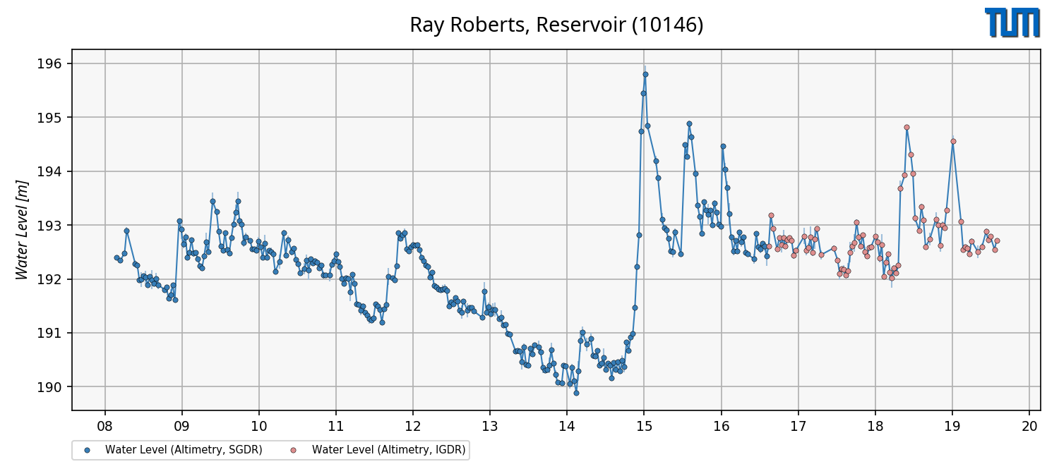
The figure (left) shows the water level time series of Ray Roberts located in the United Stats which is based on Jason-2/-3 (blue) and Jason-3 real-time data (red).
Real-time data allows us to create water level time series with a delay of 1-2 days after the altimeter satellite crossed the inland water body.
Altimeter Satellites
For the estimation of water heights, multi-mission altimeter data are used. The following figure gives an overview of the past, current and future altimeter missions since 1985.
Processing Strategy
The processing strategy of DAHITI which is described in detail in Schwatke et al. (2015) is based on an extended outlier detection and a Kalman filtering.
Data Holding
DAHITI as a global database currently provides 10745 water level time series distributed over all continents, except Antarctica.
In Africa (2136 time series), Asia (2009), Australia (54), Europe (767), North America (1514), and South America (4089) water level time series are available.
The water level time series in DAHITI are freely available and can be downloaded after a short registration process.
The amount of water level time series is permanently increasing.
Data Versions
--- Version v6.0 ---
This version uses the standard DAHITI approach described in Schwatke et al. (2015).
In this version, the following models and geophysical corrections are applied.
Correction
Source/Model
Reference
Wet Troposphere
Vienna Mapping Functions 3 (VMF3)
Landskron and Böhm, 2018
Dry Troposphere
Vienna Mapping Functions 3 (VMF3)
Landskron and Böhm, 2018
Ionosphere
NOAA Ionosphere Climatology 2009 (NIC09)
Scharro and Smith, 2010
Solid Earth Tide
IERS Convention 2010
Petit and Luzum, 2010
Pole tide
IERS Convention 2010
Petit and Luzum, 2010
Range bias
MMXO-16
Bosch et al., 2014
Geoid
EIGEN-6C4
Förste et al., 2014
Data Format
Water level time series can be download in ASCII, NetCDF, CSV and JSON format.
--- ASCII ---
# DAHITI-ID : 10146
# Target name : Ray Roberts, Reservoir
# Continent : North America
# Country : United States of America
# Longitude : -97.0557
# Latitude : 33.3615
# Points : 355
# Software : 6.0
# Download : 2020-03-09 07:44:26 (UTC)
# Dataset : water-level-altimetry
# ----------------------------------------
# column 1 : date [yyyy-mm-dd]
# column 2 : water level from altimetry [m]
# column 3 : error [m]
# ----------------------------------------
2008-07-23 192.395 0.005
2008-08-12 192.345 0.028
2008-09-01 192.481 0.021
2008-09-11 192.903 0.064
2008-10-21 192.288 0.056
...
2020-01-27 193.427 0.115
2020-02-16 192.970 0.006
2020-02-25 192.758 0.003
Don't forget to cite!
If you are using water level time series from DAHITI in your work, please cite the following publication:
Schwatke C., Dettmering D., Bosch W., and Seitz F.: DAHITI - an innovative approach for estimating water level time series over inland waters using multi-mission satellite altimetry. Hydrol. Earth Syst. Sci., 19, 4345-4364, doi:10.5194/hess-19-4345-2015, 2015