Dear DAHITI-Visitor,
we are currently revising and improving the functionality of the DAHITI website.
This concerns the following points:
New design and improved loading performance of the website.
New access control on DAHITI targets: No more target requests necessary! Instead, the download and API access is limited to 250 request within 24 hours.
New API: Switch from APIv1 to APIv2.
...
We ask for your understanding in case of temporary problems with access to DAHITI.
Please contact us in case of longer problems or if you have further questions.
Since the 1980s, optical imagery have been used to monitor surface changes of the Earth.
The extraction and identification of water bodies is essential for applications such as monitoring flooded regions and wetlands, but also for the water storage quantification of lakes and reservoirs.
Remote sensing is also capable of observing long-term geomorphological changes of rivers and their meandering.
This product provides surface area time series derived from optical imagery for lakes and reservoirs.
The temporal resolution of the surface area time series depends on the used optical imagery (e.g. 16 days for Landsat, 10 days for Sentinel-2) which can be increased by combining different missions.
The processing of the surface area time series is performed on optical imagery which have spatial resolution of 10m (Sentinel-2) and 30m (Landsat), respectively.
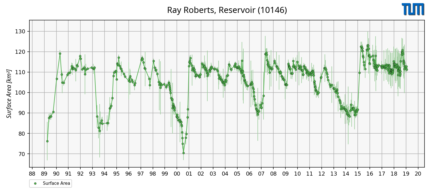
The figure (left) shows the surface area time series of Ray Roberts Lake located in the United Stats which is based on Landsat-4, Landsat-5, Landsat-7, Landsat-8, Sentinel-2A and Sentinel-2B.
Optical Imagery Satellites
For the estimation of surface areas, optical imagery data is used. The following figure gives an overview of the past, current and future optical imagery missions since 1982.
Processing Strategy
The processing strategy for of the DAHITI approach for the automated extraction of high-resolution time-variable water surfaces estimating surface area time series is described in detail in Schwatke et al. (2019).
For that purpose, optical images from Landsat and Sentinel-2 are used between January 1984 and June 2018.
The first part of this new approach is the extraction of land-water masks by combining five water indexes and using an automated threshold computation.
In the second part of this approach, all data gaps caused by voids, clouds, cloud shadows, or snow are filled by using a long-term water probability mask.
This mask is finally used in an iterative approach for filling remaining data gaps in all monthly masks which leads to a gap-less surface area time series for lakes and reservoirs.
Data Holding
DAHITI currently provides 196 surface area time series distributed over all continents, except Antarctica. In Africa (12 time series), Asia (9), Australia (1), Europe (5), North America (160), and South America (9) surface area series are available.
The surface area time series in DAHITI are freely available and can be downloaded after a short registration process.
The amount of surface area time series is permanently increasing.
Data Versions
--- Version v1.20 ---
This version uses the standard approach described in Schwatke et al. (2019). Used Data: Daily merged composites based on Landsat-4/-5/-7/-8 and Sentinel-2A/-2B scenes.
--- Version v1.00 ---
This version uses the standard approach described in Schwatke et al. (2019). Used Data: Monthly merged composites based on Landsat-4/-5/-7/-8 and Sentinel-2A/-2B scenes.
Data Format
Surface Area time series can be download in ASCII, NetCDF, CSV and JSON format.
--- ASCII ---
# DAHITI-ID : 10146
# Target name : Ray Roberts, Reservoir
# Continent : North America
# Country : United States of America
# Longitude : -97.0557
# Latitude : 33.3615
# Points : 543
# Software : 1.20
# Download : 2020-03-09 08:02:47 (UTC)
# Dataset : surface-area
# ----------------------------------------
# column 1 : date [yyyy-mm-dd]
# column 2 : surface area [km2]
# column 3 : error [km2]
# ----------------------------------------
1989-06-10 76.170 9.420
1989-07-28 87.540 2.070
1989-08-29 88.360 1.750
...
2019-03-09 111.960 1.300
2019-03-17 112.800 1.470
2019-03-25 111.230 1.410
Don't forget to cite!
If you are using surface area time series from DAHITI in your work, please cite the following publication:
Schwatke C., Scherer D., and Dettmering D.: Automated Extraction of Consistent Time-Variable Water Surfaces of Lakes and Reservoirs Based on Landsat and Sentinel-2. Remote Sensing, 11(9), 1010, doi:10.3390/rs11091010, 2019